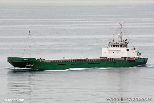
 TALIA
TALIA
Current Status
Where is the vessel?
TALIA is currently in 19 nm W of Agía Pelagía, based on AIS data received about 14h ago.
Latest AIS update:
Current position: 36.36940° N, 22.60092° E (19 nm W of Agía Pelagía)
Average speed (last 7 days): Loading…
Average speed (last 30 days): Loading…
Vessel profile: TALIA is a General Cargo with dimensions m x m.
This page combines live AIS, route history, probable destination signals, nearby traffic, and port activity for practical vessel monitoring.
The current position of vessel TALIA is 36.36940 lat / 22.60092 lng. Updated: 2026-05-19 10:08:46 UTCNearest reference points:
- 17 nm S of Areópolis
- Near Kythira
- 20 nm E of FOKIANOS
Currently sailing under the flag of Comoros ![]()
Details:
Live Vessel TALIA Analytics (details, animations, etc.)
Recent AIS points (UTC):
2026-05-19 06:58:08 UTC · 36.48479, 22.08158 · SOG 8.4 kn · COG 117°2026-05-19 08:20:57 UTC · 36.39919, 22.29984 · SOG 8.7 kn · COG 117°
2026-05-19 10:05:56 UTC · 36.36787, 22.59235 · SOG 9 kn · COG 78°
2026-05-19 10:08:46 UTC · 36.36940, 22.60092 · SOG 9.2 kn · COG 78°