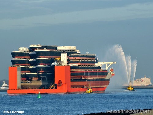
 BLUE MARLIN
Current Status
Where is the vessel?
BLUE MARLIN is currently in 34 nm NE of Sosúa, based on AIS data received about 15h ago.
Latest AIS update:
Current position: 20.21618° N, 70.17883° W (34 nm NE of Sosúa)
Average speed (last 7 days): Loading…
Average speed (last 30 days): Loading…
Vessel profile: BLUE MARLIN is a Heavy Load Carrier with dimensions 225m x 63m.
This page combines live AIS, route history, probable destination signals, nearby traffic, and port activity for practical vessel monitoring.
The current position of vessel BLUE MARLIN is 20.21618 lat / -70.17883 lng. Updated: 2026-05-19 08:08:18 UTCNearest reference points:
- Near Puerto Plata
- 38 nm SW of Cockburn Harbour
- Near Bahia De Las Calderas
Currently sailing under the flag of Malta ![]()
BLUE MARLIN built in 2000 year
Deadweight:
76061 tDetails:
Live Vessel BLUE MARLIN Analytics (details, animations, etc.)
Recent AIS points (UTC):
2026-05-19 03:48:39 UTC · 19.82452, -69.53522 · SOG 9.7 kn · COG 308°2026-05-19 05:31:19 UTC · 19.97706, -69.78473 · SOG 9.8 kn · COG 306°
2026-05-19 07:18:37 UTC · 20.14003, -70.05402 · SOG 10.1 kn · COG 302°
2026-05-19 08:08:18 UTC · 20.21618, -70.17883 · SOG 9.9 kn · COG 304°