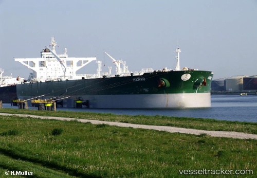
Harad
Current StatusWhere is the vessel?
Harad is currently in Near Yanbu Industrial City, based on AIS data received about 14h ago.
Latest AIS update:
Current position: 23.91947° N, 38.28238° E (Near Yanbu Industrial City)
Average speed (last 7 days): Loading…
Average speed (last 30 days): Loading…
Vessel profile: Harad is a Crude Oil Tanker with dimensions 58m x 333m.
This page combines live AIS, route history, probable destination signals, nearby traffic, and port activity for practical vessel monitoring.
The current position of vessel Harad is 23.91947 lat / 38.28238 lng. Updated: 2026-05-20 21:54:07 UTCNearest reference points:
- 30 nm SW of Yanbu
- 42 nm NW of Fiji
- 35 nm S of Umm Lajj
Details:
Live Vessel Harad Analytics (details, animations, etc.)
Recent AIS points (UTC):
2026-05-20 16:15:05 UTC · 23.96974, 38.19512 · SOG 0 kn · COG 317°2026-05-20 17:59:01 UTC · 23.93666, 38.22476 · SOG 6.8 kn · COG 127°
2026-05-20 19:33:09 UTC · 23.91981, 38.28211 · SOG 1.3 kn · COG 204°
2026-05-20 21:54:07 UTC · 23.91947, 38.28238 · SOG 0 kn · COG 204°