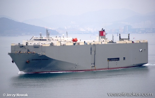
.

PA flag Caribbean Highway

Vessel type: Vehicles Carrier | IMO: 9243473 | MMSI: MMSI: 352218000
Call sign: H9ZW | Dimensions: 184 m x 32 m
Current Status

Where is the vessel?

Caribbean Highway is currently in 76 nm SE of Brebes, based on AIS data received about 15h ago.

Latest AIS update:

Current position: 5.72467° N, 110.01058° E (76 nm SE of Brebes)

Average speed (last 7 days): Loading…

Average speed (last 30 days): Loading…

Vessel profile: Caribbean Highway is a Vehicles Carrier with dimensions 184m x 32m.

This page combines live AIS, route history, probable destination signals, nearby traffic, and port activity for practical vessel monitoring.

The current position of vessel Caribbean Highway is 5.72467 lat / 110.01058 lng. Updated: 2026-05-19 11:31:48 UTC
More recent position available: 40 min ago
Free positions are delayed by 14 hours.

We recommend registering. If you register, paid vessel access will be saved in your profile. Guest access works only through a personal link.

Nearest reference points:
  • 41 nm NW of Brebes
  • 34 nm SE of Ranai
  • 11 nm N of Gombong

Currently sailing under the flag of Panama PA flag

Caribbean Highway built in 2002 year

Deadweight:
17866 t

Details:

Live Vessel Caribbean Highway Analytics (details, animations, etc.)


Recent AIS points (UTC):
2026-05-19 04:55:54 UTC · 4.40974, 109.30199 · SOG 13.5 kn · COG 30°
2026-05-19 07:56:43 UTC · 5.00036, 109.61727 · SOG 13.7 kn · COG 30°
2026-05-19 10:46:43 UTC · 5.56900, 109.92449 · SOG 14.3 kn · COG -1°
2026-05-19 11:31:48 UTC · 5.72467, 110.01058 · SOG 14.5 kn · COG -1°

UTC: --
Start: -- Track timeline (UTC) End: --
Encountered: --


Link to the map:


Find another ship

Caribbean_Highway (352218000) last ports (portcalls and passsages)

JURONG ISLAND | 2025-08-27 15:44:40
BUKOM ISLAND | 2025-08-27 14:53:13
PULAU SAMBU | 2025-08-26 16:22:19
TANAH MERAH | 2025-08-26 15:37:53
PENGERANG | 2025-08-26 14:51:02
DONGJIAKOU | 2025-08-15 12:32:46
BAKAUHENI | 2025-07-31 16:08:40
JURONG ISLAND | 2025-05-29 00:30:30
BUKOM ISLAND | 2025-05-28 23:40:31
PULAU SAMBU | 2025-05-28 23:01:33
TANAH MERAH | 2025-05-27 22:20:30
PENGERANG | 2025-05-27 21:01:37
JURONG ISLAND | 2025-02-24 16:23:39
PULAU SAMBU | 2025-02-24 15:35:26
TANAH MERAH | 2025-02-23 15:24:08
PENGERANG | 2025-02-23 13:12:28
SURALAYA | 2025-02-07 12:34:47
BAKAUHENI | 2025-02-07 11:11:49
BATU AMPAR | 2024-12-07 08:46:10
TANAH MERAH | 2024-12-05 05:13:46
LANSHAN | 2024-11-25 05:26:47
Taku Bar | 2024-11-22 21:25:47
Dagu Bar | 2024-11-19 20:16:12
Singapore | 2024-08-24 10:10:20
Lianyungang | 2024-05-03 18:34:54
Brixham | 2024-02-27 06:08:33
Ponta da Madeira | 2024-02-01 00:24:56
Sao Luiz | 2024-01-31 23:38:49
Singapore | 2023-12-21 23:21:17
Lianyungang | 2023-12-10 04:58:28
Lianyungang | 2023-12-06 03:48:18
Ponta da Madeira | 2023-10-14 05:33:34
Sao Luiz | 2023-10-14 03:27:26
Tubarao | 2023-07-15 09:33:11
Sambu | 2023-06-09 19:19:31
Taku Bar | 2023-02-07 17:34:44
Taku Bar | 2023-02-03 17:07:24
Sao Luiz | 2022-12-10 05:48:42
Singapore | 2022-11-02 23:26:30
Port Des Galets | 2022-09-27 19:35:53
Sao Luiz | 2022-09-04 10:32:29
Singapore | 2022-08-01 01:04:08
Mokpo | 2022-03-29 15:15:33