.

BM flag Lng Oyo

Vessel type: Lng Tanker | IMO: 9267003 | MMSI: MMSI: 310487000
Call sign: ZCDN4 | Dimensions: 285 m x 43 m
Current Status

Where is the vessel?

Lng Oyo is currently in 326 nm SW of Moho Bilondo, based on AIS data received about 14h ago.

Latest AIS update:

Current position: 9.66189° S, 6.27792° E (326 nm SW of Moho Bilondo)

Average speed (last 7 days): Loading…

Average speed (last 30 days): Loading…

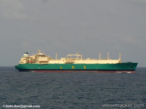
Vessel profile: Lng Oyo is a Lng Tanker with dimensions 285m x 43m.

This page combines live AIS, route history, probable destination signals, nearby traffic, and port activity for practical vessel monitoring.

The current position of vessel Lng Oyo is -9.66189 lat / 6.27792 lng. Updated: 2026-05-22 06:00:03 UTC
More recent position available: 8 min ago
Free positions are delayed by 14 hours.

We recommend registering. If you register, paid vessel access will be saved in your profile. Guest access works only through a personal link.

Nearest reference points:
  • Open sea, approx. 402 nm off the nearest listed port
  • Open sea, approx. 404 nm off the nearest listed port
  • Open sea, approx. 401 nm off the nearest listed port

Currently sailing under the flag of Bermuda BM flag

Lng Oyo built in 2005 year

Deadweight:
83068 t

Details:

Live Vessel Lng Oyo Analytics (details, animations, etc.)


Recent AIS points (UTC):
2026-05-22 03:50:57 UTC · -9.98664, 6.44136 · SOG 10.2 kn · COG 335°
2026-05-22 05:55:14 UTC · -9.67413, 6.28401 · SOG 10.2 kn · COG 336°
2026-05-22 06:00:03 UTC · -9.66189, 6.27792 · SOG 10.3 kn · COG 336°

UTC: --
Start: -- Track timeline (UTC) End: --
Encountered: --


Link to the map:


Find another ship

Lng_Oyo (310487000) last ports (portcalls and passsages)

SAINT LOUIS DU RHONE | 2025-08-18 14:23:00
LAVERA | 2025-08-18 12:21:11
Ceuta | 2025-08-16 12:32:10
Strait Of Gibraltar | 2025-08-16 11:27:41
Bonny | 2025-08-05 20:58:03
DAHEJ | 2025-06-13 00:32:54
Bonny | 2025-05-17 06:22:38
Bonny | 2025-04-11 09:09:31
PEMBROKE | 2025-01-29 17:43:29
Milford Haven | 2025-01-29 17:06:32
Bonny | 2025-01-16 00:23:23
JURONG ISLAND | 2024-11-28 17:06:38
BUKOM ISLAND | 2024-11-27 07:18:43
TANAH MERAH | 2024-11-27 05:39:38
PENGERANG | 2024-11-27 04:08:09
PENGERANG | 2024-11-09 09:06:11
PULAU SAMBU | 2024-11-09 07:54:04
Bonny | 2024-10-15 08:41:43
Huelva | 2024-07-25 05:07:51
Bonny | 2024-07-10 17:17:52
Port Louis | 2024-06-22 04:14:18
Port Louis | 2024-05-30 17:12:03
Bonny | 2024-05-17 19:40:13
Singapore | 2024-03-23 22:16:26
Map Ta Phut | 2024-03-20 00:41:23
Port Louis | 2024-03-08 04:32:09
Bonny | 2024-02-19 20:09:22
Bonny | 2024-01-21 19:56:23
Bonny | 2023-12-10 21:13:30
Cape Of Good Hope | 2023-11-26 16:08:34
Singapore | 2023-11-08 22:14:55
Selat Lombok | 2023-10-23 12:06:51
Bonny | 2023-10-01 14:17:56
Huelva | 2023-09-07 08:05:19
Bonny | 2023-08-13 12:57:24
Muuga-Port Of Tallinn | 2023-08-11 22:45:04
Bonny | 2023-06-16 12:30:14
Mina Saud | 2023-05-18 01:10:48
Bonny | 2023-04-11 03:55:18
Bonny | 2023-03-10 05:41:33
Bonny | 2022-12-26 05:03:07
St. Louis Du Rhone | 2022-12-11 14:03:18
Bonny | 2022-11-25 14:42:45
Huelva | 2022-11-15 15:05:11
Bonny | 2022-10-29 13:09:20
Bonny | 2022-09-19 10:13:40
Mina Saud | 2022-08-09 22:32:11
Bonny | 2022-07-17 02:03:25
Mina Saud | 2022-06-21 22:08:55
Bonny | 2022-05-18 01:47:10
Bonny | 2022-04-12 00:40:07
Sambu | 2022-02-28 00:30:12
Bonny | 2022-02-04 18:05:07
Port Louis | 2022-01-20 08:40:15
Bonny | 2021-12-19 12:10:00