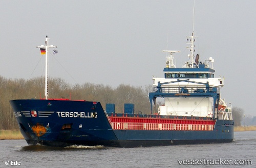
 Terschelling
Current Status
Where is the vessel?
Terschelling is currently in Near Calais, based on AIS data received about 15h ago.
Latest AIS update:
Current position: 51.08637° N, 1.90096° E (Near Calais)
Average speed (last 7 days): Loading…
Average speed (last 30 days): Loading…
Vessel profile: Terschelling is a Multi Purpose Carrier with dimensions 111m x 111m.
This page combines live AIS, route history, probable destination signals, nearby traffic, and port activity for practical vessel monitoring.
The current position of vessel Terschelling is 51.08637 lat / 1.90096 lng. Updated: 2026-05-21 14:03:36 UTCNearest reference points:
- Near Calais
- 14 nm SE of RAMSGATE
- 15 nm E of RAMSGATE
Currently sailing under the flag of Netherlands ![]()
Terschelling built in 2005 year
Deadweight:
6000 tDetails:
Live Vessel Terschelling Analytics (details, animations, etc.)
Recent AIS points (UTC):
2026-05-21 11:03:31 UTC · 51.08533, 1.89646 · SOG 0 kn · COG 46°2026-05-21 11:30:31 UTC · 51.08543, 1.89657 · SOG 0 kn · COG 41°
2026-05-21 13:39:31 UTC · 51.08615, 1.90069 · SOG 0.2 kn · COG 252°
2026-05-21 14:03:36 UTC · 51.08637, 1.90096 · SOG 0.4 kn · COG 269°