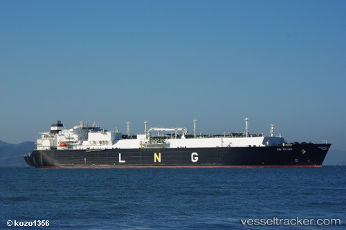
 OB RIVER
Current Status
Where is the vessel?
OB RIVER is currently in 32 nm SE of Geomundo, based on AIS data received about 14h ago.
Latest AIS update:
Current position: 33.65399° N, 127.78017° E (32 nm SE of Geomundo)
Average speed (last 7 days): Loading…
Average speed (last 30 days): Loading…
Vessel profile: OB RIVER is a LNG Tanker with dimensions 288m x 44m.
This page combines live AIS, route history, probable destination signals, nearby traffic, and port activity for practical vessel monitoring.
The current position of vessel OB RIVER is 33.65399 lat / 127.78017 lng. Updated: 2026-05-20 10:06:06 UTCNearest reference points:
- 35 nm E of Geomundo
- 12 nm E of Geomundo
- 25 nm S of Kukdo
Currently sailing under the flag of Marshall Islands ![]()
OB RIVER built in 2007 year
Deadweight:
84682 tDetails:
Live Vessel OB RIVER Analytics (details, animations, etc.)
Recent AIS points (UTC):
2026-05-20 07:48:17 UTC · 34.02313, 127.92730 · SOG 0.1 kn · COG 114°2026-05-20 07:48:17 UTC · 34.02313, 127.92730 · SOG 0.1 kn · COG 114°
2026-05-20 09:34:23 UTC · 33.74207, 127.82746 · SOG 12.1 kn · COG 210°
2026-05-20 10:06:06 UTC · 33.65399, 127.78017 · SOG 12.6 kn · COG -1°