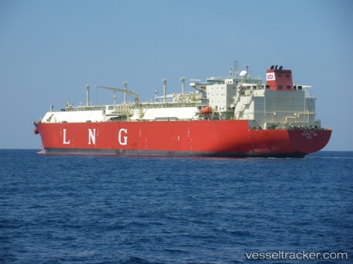
.

Lng Kolt

Vessel type: Lng Tanker | IMO: 9372963 | MMSI: MMSI: 370799000
Call sign: 3FNM7 | Dimensions: 44 m x 278 m
Current Status

Where is the vessel?

Lng Kolt is currently in 191 nm N of Itarema, based on AIS data received about 15h ago.

Latest AIS update:

Current position: 0.08260° N, 38.87887° W (191 nm N of Itarema)

Average speed (last 7 days): Loading…

Average speed (last 30 days): Loading…

Vessel profile: Lng Kolt is a Lng Tanker with dimensions 44m x 278m.

This page combines live AIS, route history, probable destination signals, nearby traffic, and port activity for practical vessel monitoring.

The current position of vessel Lng Kolt is 0.08260 lat / -38.87887 lng. Updated: 2026-05-20 04:31:24 UTC
More recent position available: 19 min ago
Free positions are delayed by 14 hours.

We recommend registering. If you register, paid vessel access will be saved in your profile. Guest access works only through a personal link.

Nearest reference points:
  • 141 nm N of Itarema
  • 169 nm N of Pecém Pt/São Gonçalo do Amarante
  • 81 nm N of Acarau
Details:

Live Vessel Lng Kolt Analytics (details, animations, etc.)


Recent AIS points (UTC):
2026-05-20 01:52:38 UTC · 0.53558, -39.43513 · SOG 16.1 kn · COG 130°
2026-05-20 02:13:05 UTC · 0.47698, -39.36383 · SOG 16.3 kn · COG 129°
2026-05-20 03:20:33 UTC · 0.28343, -39.12795 · SOG 16.3 kn · COG 129°
2026-05-20 04:31:24 UTC · 0.08260, -38.87887 · SOG 16 kn · COG 129°

UTC: --
Start: -- Track timeline (UTC) End: --
Encountered: --


Link to the map:


Find another ship

Lng_Kolt (370799000) last ports (portcalls and passsages)

SABINE PASS | 2025-08-14 12:09:24
DAESAN | 2025-07-02 04:24:11
PYEONGTAEK | 2025-06-30 22:00:15
BAKAUHENI | 2025-06-22 10:46:13
SABINE PASS | 2025-05-18 21:52:44
JURONG ISLAND | 2025-04-06 02:06:22
BUKOM ISLAND | 2025-04-02 09:30:34
Singapore | 2025-04-02 08:22:50
BATU AMPAR | 2025-04-02 07:41:11
TANAH MERAH | 2025-04-02 07:04:42
PENGERANG | 2025-04-02 06:16:28
Map Ta Phut | 2025-03-30 05:40:20
TANAH MERAH | 2025-03-28 03:34:50
BATU AMPAR | 2025-03-28 03:12:48
SABINE PASS | 2025-02-18 23:35:51
OKPO | 2024-12-31 01:58:58
PYEONGTAEK | 2024-12-27 04:37:19
DAESAN | 2024-12-27 02:39:25
GLADSTONE | 2024-12-13 01:59:34
PYEONGTAEK | 2024-11-30 05:53:57
DAESAN | 2024-11-30 04:06:13
GLADSTONE | 2024-11-16 03:57:49
Gladstone Harbor | 2024-10-18 15:30:40
Gladstone Harbor | 2024-09-21 16:42:48
Gladstone Harbor | 2024-08-26 09:46:14
Gladstone Harbor | 2024-07-30 14:25:02
Gladstone Harbor | 2024-07-05 15:31:03
Gladstone Harbor | 2024-06-07 15:59:49
Gladstone Harbor | 2024-05-10 16:28:01
Gladstone Harbor | 2024-04-13 17:24:39
Gladstone Harbor | 2024-02-17 23:10:12
Gladstone Harbor | 2024-01-21 11:57:51
Gladstone Harbor | 2023-12-24 00:05:20
Gladstone Harbor | 2023-11-26 14:20:49
Torres Strait | 2023-11-19 00:10:27
Sambu | 2023-11-11 07:20:51
Singapore | 2023-10-02 03:05:38
Gladstone Harbor | 2023-09-12 14:15:00
Gladstone Harbor | 2023-08-17 16:08:05
Gladstone Harbor | 2023-07-24 06:45:31
Gladstone Harbor | 2023-06-28 23:08:58
Gladstone Harbor | 2023-05-09 18:23:03
Gladstone Harbor | 2023-04-15 11:36:36
Gladstone Harbor | 2023-03-16 11:20:48
Gladstone Harbor | 2023-02-20 18:09:48
Gladstone Harbor | 2023-01-24 17:56:02
Gladstone Harbor | 2022-12-25 11:59:33
Gladstone Harbor | 2022-12-01 11:18:20
Gladstone Harbor | 2022-11-07 03:01:25
Gladstone Harbor | 2022-10-13 07:09:49
Gladstone Harbor | 2022-09-17 07:02:51
Gladstone Harbor | 2022-08-21 13:23:17
Gladstone Harbor | 2022-06-27 16:56:24
Gladstone Harbor | 2022-06-02 07:10:41
Gladstone Harbor | 2022-05-08 11:03:28
Gladstone Harbor | 2022-01-04 05:00:07