 Frauke
Current Status
Where is the vessel?
Frauke is currently in 382 nm NE of Levelwood, based on AIS data received about 14h ago.
Latest AIS update:
Current position: 12.01308° S, 0.01675° E (382 nm NE of Levelwood)
Average speed (last 7 days): Loading…
Average speed (last 30 days): Loading…
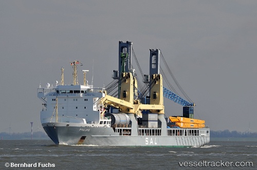
Vessel profile: Frauke is a Heavy Load Carrier with dimensions 160m x 24m.
This page combines live AIS, route history, probable destination signals, nearby traffic, and port activity for practical vessel monitoring.
The current position of vessel Frauke is -12.01308 lat / 0.01675 lng. Updated: 2026-05-23 01:37:43 UTCNearest reference points:
- Open sea, approx. 401 nm off the nearest listed port
- Open sea, approx. 400 nm off the nearest listed port
- Open sea, approx. 402 nm off the nearest listed port
Currently sailing under the flag of Antigua Barbuda ![]()
Frauke built in 2008 year
Deadweight:
12007 tDetails:
Live Vessel Frauke Analytics (details, animations, etc.)
Recent AIS points (UTC):
2026-05-22 23:07:31 UTC · -12.61508, 0.48943 · SOG 18.2 kn · COG 322°2026-05-22 23:28:55 UTC · -12.52939, 0.42095 · SOG 18 kn · COG 323°
2026-05-23 01:30:44 UTC · -12.04060, 0.03850 · SOG 17.9 kn · COG 323°
2026-05-23 01:37:43 UTC · -12.01308, 0.01675 · SOG 17.9 kn · COG 323°