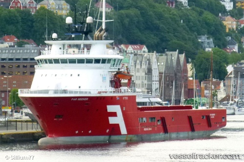
 SEEKER TIDE
Current Status
Where is the vessel?
SEEKER TIDE is currently in Near Muara, based on AIS data received about 15h ago.
Latest AIS update:
Current position: 5.00762° N, 115.06601° E (Near Muara)
Average speed (last 7 days): Loading…
Average speed (last 30 days): Loading…
Vessel profile: SEEKER TIDE is a Offshore Supply Ship with dimensions m x m.
This page combines live AIS, route history, probable destination signals, nearby traffic, and port activity for practical vessel monitoring.
The current position of vessel SEEKER TIDE is 5.00762 lat / 115.06601 lng. Updated: 2026-05-21 12:12:13 UTCNearest reference points:
- Near Kikeh
- 11 nm N of MIRI
- Near MIRI
Currently sailing under the flag of United Kingdom ![]()
Details:
Live Vessel SEEKER TIDE Analytics (details, animations, etc.)
Recent AIS points (UTC):
2026-05-21 08:03:53 UTC · 5.00667, 115.06500 · SOG 0 kn · COG -1°2026-05-21 09:24:12 UTC · 5.00761, 115.06603 · SOG 0 kn · COG 182°
2026-05-21 10:12:16 UTC · 5.00763, 115.06604 · SOG 0 kn · COG 182°
2026-05-21 12:12:13 UTC · 5.00762, 115.06601 · SOG 0 kn · COG 182°