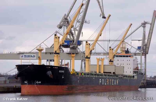
 RESKO
RESKO
Current Status
Where is the vessel?
RESKO is currently in 30 nm SW of Rivière-au-Tonnerre, based on AIS data received about 14h ago.
Latest AIS update:
Current position: 49.86547° N, 65.22227° W (30 nm SW of Rivière-au-Tonnerre)
Average speed (last 7 days): Loading…
Average speed (last 30 days): Loading…
Vessel profile: RESKO is a Bulk Carrier with dimensions m x m.
This page combines live AIS, route history, probable destination signals, nearby traffic, and port activity for practical vessel monitoring.
The current position of vessel RESKO is 49.86547 lat / -65.22227 lng. Updated: 2026-05-22 19:55:32 UTCNearest reference points:
- 22 nm N of Sainte-Anne-des-Monts
Currently sailing under the flag of Malta ![]()
Details:
Live Vessel RESKO Analytics (details, animations, etc.)
Recent AIS points (UTC):
2026-05-22 16:02:42 UTC · 50.08822, -64.39833 · SOG 9.9 kn · COG 258°2026-05-22 17:26:42 UTC · 50.00550, -64.71232 · SOG 9.3 kn · COG 250°
2026-05-22 19:05:41 UTC · 49.90873, -65.05303 · SOG 8.5 kn · COG 250°
2026-05-22 19:55:32 UTC · 49.86547, -65.22227 · SOG 8.3 kn · COG 245°