 vesseltracker.com
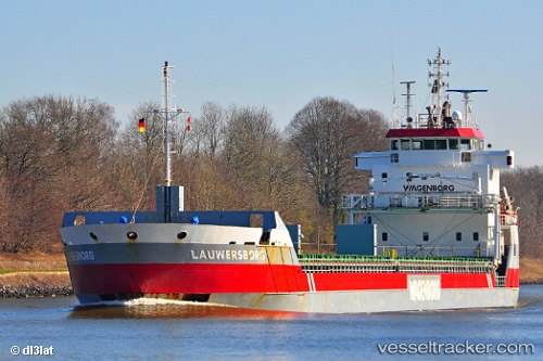
 Lauwersborg
Current Status
Where is the vessel?
Lauwersborg is currently in Near Herøya, based on AIS data received about 14h ago.
Latest AIS update:
Current position: 59.11769° N, 9.62087° E (Near Herøya)
Average speed (last 7 days): Loading…
Average speed (last 30 days): Loading…
Vessel profile: Lauwersborg is a Multi Purpose Carrier with dimensions 123m x 14m.
This page combines live AIS, route history, probable destination signals, nearby traffic, and port activity for practical vessel monitoring.
The current position of vessel Lauwersborg is 59.11769 lat / 9.62087 lng. Updated: 2026-05-18 03:42:47 UTCNearest reference points:
- Near Rønningen
- Near SANDEFJORD
- Near Thorøya
Currently sailing under the flag of Netherlands ![]()
Lauwersborg built in 2007 year
Deadweight:
7350 tDetails:
Live Vessel Lauwersborg Analytics (details, animations, etc.)
Recent AIS points (UTC):
2026-05-17 23:21:48 UTC · 59.11783, 9.62037 · SOG 0 kn · COG 122°2026-05-18 01:45:50 UTC · 59.11782, 9.62040 · SOG 0 kn · COG 122°
2026-05-18 02:12:45 UTC · 59.11782, 9.62037 · SOG 0 kn · COG 122°
2026-05-18 03:42:47 UTC · 59.11769, 9.62087 · SOG 0 kn · COG 121°