 vesseltracker.com
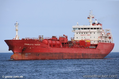
 Charlotte Theresa
Current Status
Where is the vessel?
Charlotte Theresa is currently in 30 nm NW of Town Quays/Drogheda, based on AIS data received about 14h ago.
Latest AIS update:
Current position: 54.15457° N, 5.91601° E (30 nm NW of Town Quays/Drogheda)
Average speed (last 7 days): Loading…
Average speed (last 30 days): Loading…
Vessel profile: Charlotte Theresa is a Chemical Oil Products Tanker with dimensions 130m x 19m.
This page combines live AIS, route history, probable destination signals, nearby traffic, and port activity for practical vessel monitoring.
The current position of vessel Charlotte Theresa is 54.15457 lat / 5.91601 lng. Updated: 2026-05-18 02:13:06 UTCNearest reference points:
- 14 nm NW of Town Quays/Drogheda
- Near Hempens
- Near LEEUWARDEN
Currently sailing under the flag of Denmark ![]()
Charlotte Theresa built in 2008 year
Deadweight:
11372 tDetails:
Live Vessel Charlotte Theresa Analytics (details, animations, etc.)
Recent AIS points (UTC):
2026-05-17 22:42:57 UTC · 54.18952, 6.46453 · SOG 5.4 kn · COG 268°2026-05-17 23:23:26 UTC · 54.18792, 6.35779 · SOG 5.3 kn · COG 269°
2026-05-18 01:47:48 UTC · 54.16207, 5.98226 · SOG 5.7 kn · COG 254°
2026-05-18 02:13:06 UTC · 54.15457, 5.91601 · SOG 5.4 kn · COG 256°