 vesseltracker.com
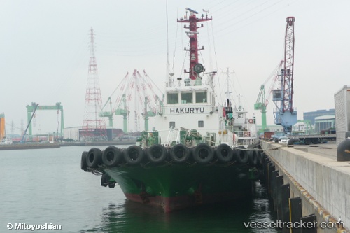
 HAKURYU MARU
Current Status
Where is the vessel?
HAKURYU MARU is currently in Near Itoshima, Fukuoka, based on AIS data received about 14h ago.
Latest AIS update:
Current position: 33.67413° N, 130.17220° E (Near Itoshima, Fukuoka)
Average speed (last 7 days): Loading…
Average speed (last 30 days): Loading…
Vessel profile: HAKURYU MARU is a Tug with dimensions m x m.
This page combines live AIS, route history, probable destination signals, nearby traffic, and port activity for practical vessel monitoring.
The current position of vessel HAKURYU MARU is 33.67413 lat / 130.17220 lng. Updated: 2026-05-18 14:12:22 UTCNearest reference points:
- Near Hakata
- 17 nm NW of Tobo
- Near Hibiki-Nada
Currently sailing under the flag of Japan ![]()
Details:
Live Vessel HAKURYU MARU Analytics (details, animations, etc.)
Recent AIS points (UTC):
2026-05-18 10:42:03 UTC · 33.34167, 129.56168 · SOG 12 kn · COG -1°2026-05-18 11:49:12 UTC · 33.49127, 129.72729 · SOG 10.2 kn · COG 50°
2026-05-18 13:43:02 UTC · 33.62695, 130.08200 · SOG 10.7 kn · COG 69°
2026-05-18 14:12:22 UTC · 33.67413, 130.17220 · SOG 11.1 kn · COG 52°