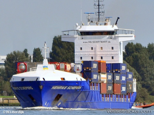
Henrike Schepers
Current StatusWhere is the vessel?
Henrike Schepers is currently in 21 nm SW of Ferrybridge, based on AIS data received about 14h ago.
Latest AIS update:
Current position: 50.25570° N, 2.72280° W (21 nm SW of Ferrybridge)
Average speed (last 7 days): Loading…
Average speed (last 30 days): Loading…
Vessel profile: Henrike Schepers is a Container Ship with dimensions 22m x 141m.
This page combines live AIS, route history, probable destination signals, nearby traffic, and port activity for practical vessel monitoring.
The current position of vessel Henrike Schepers is 50.25570 lat / -2.72280 lng. Updated: 2026-05-18 20:01:25 UTCNearest reference points:
- 16 nm SE of Brixham
- Near Castletown
- Near WEYMOUTH
Details:
Live Vessel Henrike Schepers Analytics (details, animations, etc.)
Recent AIS points (UTC):
2026-05-18 16:24:02 UTC · 50.03532, -4.28047 · SOG 16 kn · COG 81°2026-05-18 18:00:10 UTC · 50.12444, -3.60431 · SOG 17.2 kn · COG 83°
2026-05-18 19:38:56 UTC · 50.23209, -2.88941 · SOG 17.4 kn · COG 77°
2026-05-18 20:01:25 UTC · 50.25570, -2.72280 · SOG 17.5 kn · COG 77°