 Tamiat Navigator
Current Status
Where is the vessel?
Tamiat Navigator is currently in 32 nm W of Cape Ray, based on AIS data received about 14h ago.
Latest AIS update:
Current position: 47.64833° N, 60.08667° W (32 nm W of Cape Ray)
Average speed (last 7 days): Loading…
Average speed (last 30 days): Loading…
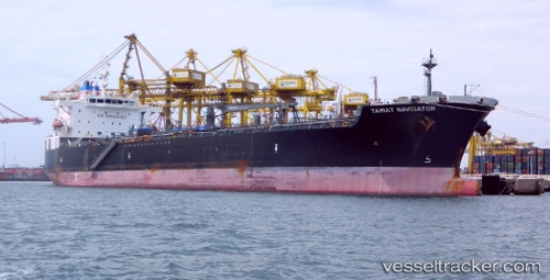
Vessel profile: Tamiat Navigator is a Chemical Oil Products Tanker with dimensions 183m x 32m.
This page combines live AIS, route history, probable destination signals, nearby traffic, and port activity for practical vessel monitoring.
The current position of vessel Tamiat Navigator is 47.64833 lat / -60.08667 lng. Updated: 2026-05-19 12:18:38 UTCNearest reference points:
- Near Corner Brook
- Near Goldboro
Currently sailing under the flag of Panama ![]()
Tamiat Navigator built in 2010 year
Deadweight:
46625 tDetails:
Live Vessel Tamiat Navigator Analytics (details, animations, etc.)
Recent AIS points (UTC):
2026-05-19 07:30:34 UTC · 48.05833, -61.08167 · SOG 11 kn · COG -1°2026-05-19 10:01:43 UTC · 47.83084, -60.55549 · SOG 9.6 kn · COG 121°
2026-05-19 10:12:35 UTC · 47.81500, -60.51833 · SOG 9 kn · COG -1°
2026-05-19 12:18:38 UTC · 47.64833, -60.08667 · SOG 9 kn · COG -1°