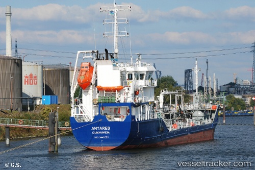
 ANTARES
Current Status
Where is the vessel?
ANTARES is currently in Near Immingham, based on AIS data received about 14h ago.
Latest AIS update:
Current position: 53.62860° N, 0.16822° W (Near Immingham)
Average speed (last 7 days): Loading…
Average speed (last 30 days): Loading…
Vessel profile: ANTARES is a Oil/Chemical Tanker with dimensions m x m.
This page combines live AIS, route history, probable destination signals, nearby traffic, and port activity for practical vessel monitoring.
The current position of vessel ANTARES is 53.62860 lat / -0.16822 lng. Updated: 2026-05-20 16:58:03 UTCNearest reference points:
- Near Immingham
- Near Grimsby
- Near Hull
Currently sailing under the flag of Portugal ![]()
Details:
Live Vessel ANTARES Analytics (details, animations, etc.)
Recent AIS points (UTC):
2026-05-20 13:25:12 UTC · 53.57248, 0.41206 · SOG 5.2 kn · COG 191°2026-05-20 13:51:29 UTC · 53.55523, 0.34088 · SOG 7.5 kn · COG 258°
2026-05-20 16:04:48 UTC · 53.62842, -0.13955 · SOG 8.4 kn · COG 291°
2026-05-20 16:58:03 UTC · 53.62860, -0.16822 · SOG 0 kn · COG 112°