 CAPE GOOD HOPE
Current Status
Where is the vessel?
CAPE GOOD HOPE is currently in 41 nm SE of Hua-Lien Kang, based on AIS data received about 14h ago.
Latest AIS update:
Current position: 23.48782° N, 122.13395° E (41 nm SE of Hua-Lien Kang)
Average speed (last 7 days): Loading…
Average speed (last 30 days): Loading…
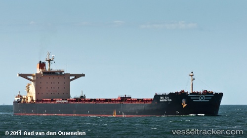
Vessel profile: CAPE GOOD HOPE is a Bulk Carrier with dimensions m x m.
This page combines live AIS, route history, probable destination signals, nearby traffic, and port activity for practical vessel monitoring.
The current position of vessel CAPE GOOD HOPE is 23.48782 lat / 122.13395 lng. Updated: 2026-05-21 21:33:12 UTCNearest reference points:
- 26 nm E of Hua-Lien Kang
- 55 nm S of Hua-Lien Kang
- Near SUAO
Currently sailing under the flag of Liberia ![]()
Details:
Live Vessel CAPE GOOD HOPE Analytics (details, animations, etc.)
Recent AIS points (UTC):
2026-05-21 18:24:52 UTC · 24.08320, 122.31045 · SOG 11.8 kn · COG 199°2026-05-21 19:24:21 UTC · 23.89233, 122.25245 · SOG 11.8 kn · COG 193°
2026-05-21 19:39:43 UTC · 23.84363, 122.23923 · SOG 11.6 kn · COG 193°
2026-05-21 21:33:12 UTC · 23.48782, 122.13395 · SOG 11.7 kn · COG 193°