Shirara
Current StatusWhere is the vessel?
Shirara is currently in 359 nm SW of Georgetown, based on AIS data received about 14h ago.
Latest AIS update:
Current position: 12.97337° S, 17.66530° W (359 nm SW of Georgetown)
Average speed (last 7 days): Loading…
Average speed (last 30 days): Loading…
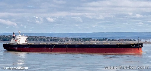
Vessel profile: Shirara is a Bulk Carrier with dimensions 45m x 289m.
This page combines live AIS, route history, probable destination signals, nearby traffic, and port activity for practical vessel monitoring.
The current position of vessel Shirara is -12.97337 lat / -17.66530 lng. Updated: 2026-05-21 13:11:02 UTCNearest reference points:
- Open sea, approx. 402 nm off the nearest listed port
- Open sea, approx. 406 nm off the nearest listed port
- Open sea, approx. 403 nm off the nearest listed port
Details:
Live Vessel Shirara Analytics (details, animations, etc.)
Recent AIS points (UTC):
2026-05-21 09:59:17 UTC · -12.62995, -18.19587 · SOG 11.6 kn · COG 120°2026-05-21 11:06:41 UTC · -12.75065, -18.01037 · SOG 11.7 kn · COG 121°
2026-05-21 12:24:38 UTC · -12.89037, -17.79425 · SOG 11.6 kn · COG 120°
2026-05-21 13:11:02 UTC · -12.97337, -17.66530 · SOG 11.6 kn · COG 120°