 VIKING EMERALD
Current Status
Where is the vessel?
VIKING EMERALD is currently in 53 nm NE of Espírito Santo FPSO, based on AIS data received about 14h ago.
Latest AIS update:
Current position: 20.63500° S, 39.00833° W (53 nm NE of Espírito Santo FPSO)
Average speed (last 7 days): Loading…
Average speed (last 30 days): Loading…
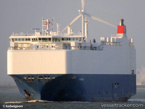
Vessel profile: VIKING EMERALD is a Vehicles Carrier with dimensions 28m x 167m.
This page combines live AIS, route history, probable destination signals, nearby traffic, and port activity for practical vessel monitoring.
The current position of vessel VIKING EMERALD is -20.63500 lat / -39.00833 lng. Updated: 2026-05-20 07:01:01 UTCNearest reference points:
- 66 nm NE of Espírito Santo FPSO
- Near Tubarão Pt./Vitória
- Near Capixaba FPSO
Currently sailing under the flag of Marshall Islands ![]()
VIKING EMERALD built in 2012 year
Deadweight:
12459 tDetails:
Live Vessel VIKING EMERALD Analytics (details, animations, etc.)
Recent AIS points (UTC):
2026-05-20 03:25:00 UTC · -20.86228, -38.13440 · SOG 14 kn · COG 287°2026-05-20 04:28:37 UTC · -20.78329, -38.38446 · SOG 14.1 kn · COG 284°
2026-05-20 05:54:58 UTC · -20.70500, -38.73667 · SOG 14 kn · COG -1°
2026-05-20 07:01:01 UTC · -20.63500, -39.00833 · SOG 14 kn · COG -1°