 vesseltracker.com
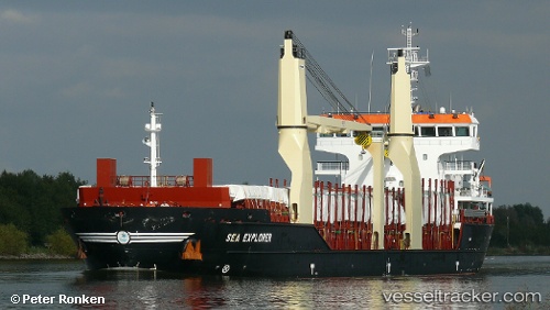
 SEA EXPLORER
Current Status
Where is the vessel?
SEA EXPLORER is currently in Near Bejaia, based on AIS data received about 14h ago.
Latest AIS update:
Current position: 36.75171° N, 5.08759° E (Near Bejaia)
Average speed (last 7 days): Loading…
Average speed (last 30 days): Loading…
Vessel profile: SEA EXPLORER is a General Cargo with dimensions m x m.
This page combines live AIS, route history, probable destination signals, nearby traffic, and port activity for practical vessel monitoring.
The current position of vessel SEA EXPLORER is 36.75171 lat / 5.08759 lng. Updated: 2026-05-18 14:15:59 UTCNearest reference points:
- Near Bejaia
- Near Carmona
- Near Zamoranos
Currently sailing under the flag of Portugal ![]()
Details:
Live Vessel SEA EXPLORER Analytics (details, animations, etc.)
Recent AIS points (UTC):
2026-05-18 10:48:54 UTC · 36.75169, 5.08756 · SOG 0 kn · COG 226°2026-05-18 11:54:55 UTC · 36.75168, 5.08755 · SOG 0 kn · COG 226°
2026-05-18 13:33:58 UTC · 36.75169, 5.08756 · SOG 0 kn · COG 226°
2026-05-18 14:15:59 UTC · 36.75171, 5.08759 · SOG 0 kn · COG 226°