 vesseltracker.com
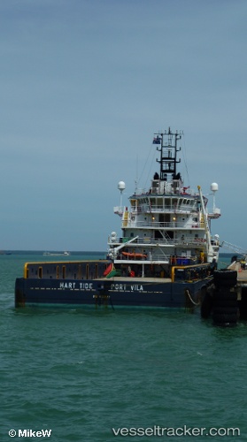
 HART TIDE
Current Status
Where is the vessel?
HART TIDE is currently in 48 nm E of Handil, based on AIS data received about 14h ago.
Latest AIS update:
Current position: 0.88891° S, 118.05818° E (48 nm E of Handil)
Average speed (last 7 days): Loading…
Average speed (last 30 days): Loading…
Vessel profile: HART TIDE is a Offshore Supply Ship with dimensions m x m.
This page combines live AIS, route history, probable destination signals, nearby traffic, and port activity for practical vessel monitoring.
The current position of vessel HART TIDE is -0.88891 lat / 118.05818 lng. Updated: 2026-05-18 10:25:23 UTCNearest reference points:
- 24 nm E of Handil
- 56 nm SE of Santan Terminal
- 22 nm NE of Handil
Currently sailing under the flag of Indonesia ![]()
Details:
Live Vessel HART TIDE Analytics (details, animations, etc.)
Recent AIS points (UTC):
2026-05-18 07:08:34 UTC · -0.98073, 117.84874 · SOG 4.1 kn · COG 60°2026-05-18 07:55:54 UTC · -0.95750, 117.89843 · SOG 4.3 kn · COG 66°
2026-05-18 09:26:13 UTC · -0.91518, 117.99956 · SOG 4.3 kn · COG 62°
2026-05-18 10:25:23 UTC · -0.88891, 118.05818 · SOG 3.5 kn · COG 60°