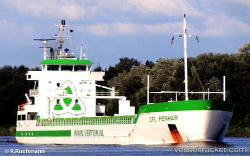
 Penhar
Current Status
Where is the vessel?
Penhar is currently in Near Paramaribo Zorg en Hoop Airport, based on AIS data received about 14h ago.
Latest AIS update:
Current position: 5.77333° N, 55.15167° W (Near Paramaribo Zorg en Hoop Airport)
Average speed (last 7 days): Loading…
Average speed (last 30 days): Loading…
Vessel profile: Penhar is a Multi Purpose Carrier with dimensions 119m x 14m.
This page combines live AIS, route history, probable destination signals, nearby traffic, and port activity for practical vessel monitoring.
The current position of vessel Penhar is 5.77333 lat / -55.15167 lng. Updated: 2026-05-21 17:27:08 UTCNearest reference points:
- Near Paramaribo Zorg en Hoop Airport
- 38 nm NW of Jarikaba
Currently sailing under the flag of Netherlands ![]()
Penhar built in 2010 year
Deadweight:
6500 tDetails:
Live Vessel Penhar Analytics (details, animations, etc.)
Recent AIS points (UTC):
2026-05-21 14:03:41 UTC · 5.77430, -55.15246 · SOG 0 kn · COG 319°2026-05-21 15:45:08 UTC · 5.77333, -55.15167 · SOG 0 kn · COG -1°
2026-05-21 16:24:44 UTC · 5.77431, -55.15248 · SOG 0 kn · COG 319°
2026-05-21 17:27:08 UTC · 5.77333, -55.15167 · SOG 0 kn · COG -1°