 vesseltracker.com
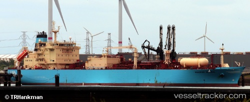
 NAVIGATOR GLOBAL
Current Status
Where is the vessel?
NAVIGATOR GLOBAL is currently in Near MOIN, based on AIS data received about 15h ago.
Latest AIS update:
Current position: 10.00804° N, 83.07732° W (Near MOIN)
Average speed (last 7 days): Loading…
Average speed (last 30 days): Loading…
Vessel profile: NAVIGATOR GLOBAL is a Lpg Tanker with dimensions m x m.
This page combines live AIS, route history, probable destination signals, nearby traffic, and port activity for practical vessel monitoring.
The current position of vessel NAVIGATOR GLOBAL is 10.00804 lat / -83.07732 lng. Updated: 2026-05-17 22:14:12 UTCNearest reference points:
- Near Chiriquí Grande
Currently sailing under the flag of Liberia ![]()
Details:
Live Vessel NAVIGATOR GLOBAL Analytics (details, animations, etc.)
Recent AIS points (UTC):
2026-05-17 20:02:12 UTC · 10.00802, -83.07729 · SOG 0.1 kn · COG 317°2026-05-17 22:08:12 UTC · 10.00804, -83.07730 · SOG 0.1 kn · COG 317°
2026-05-17 22:14:12 UTC · 10.00804, -83.07732 · SOG 0.1 kn · COG 317°
2026-05-17 22:14:12 UTC · 10.00804, -83.07732 · SOG 0.1 kn · COG 317°