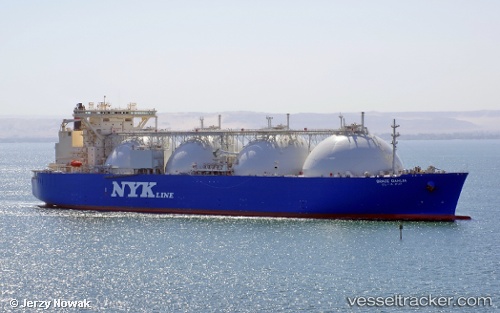
Grace Dahlia
Current StatusWhere is the vessel?
Grace Dahlia is currently in 206 nm NW of Amini Island, based on AIS data received about 14h ago.
Latest AIS update:
Current position: 13.59833° N, 70.31667° E (206 nm NW of Amini Island)
Average speed (last 7 days): Loading…
Average speed (last 30 days): Loading…
Vessel profile: Grace Dahlia is a Lng Tanker with dimensions 52m x 300m.
This page combines live AIS, route history, probable destination signals, nearby traffic, and port activity for practical vessel monitoring.
The current position of vessel Grace Dahlia is 13.59833 lat / 70.31667 lng. Updated: 2026-05-18 22:02:56 UTCNearest reference points:
- 202 nm NW of Amini Island
- 198 nm N of Tinaquillo
- 89 nm W of Marmagao (Marmugao)
Details:
Live Vessel Grace Dahlia Analytics (details, animations, etc.)
Recent AIS points (UTC):
2026-05-18 19:41:51 UTC · 13.09333, 70.31500 · SOG 12 kn · COG -1°2026-05-18 19:56:49 UTC · 13.14667, 70.31500 · SOG 12 kn · COG -1°
2026-05-18 21:47:50 UTC · 13.54500, 70.31667 · SOG 13 kn · COG -1°
2026-05-18 22:02:56 UTC · 13.59833, 70.31667 · SOG 12 kn · COG -1°