.

MH flag SEA MARANHAO

Vessel type: Ore Carrier | IMO: 9575515 | MMSI: MMSI: 538008959
Call sign: V7A2951 | Dimensions: 65 m x 361 m
Current Status

Where is the vessel?

SEA MARANHAO is currently in 359 nm N of Windermere, based on AIS data received about 15h ago.

Latest AIS update:

Current position: 28.28901° S, 16.15801° W (359 nm N of Windermere)

Average speed (last 7 days): Loading…

Average speed (last 30 days): Loading…

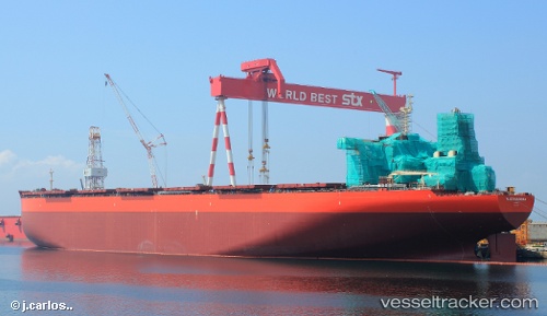
Vessel profile: SEA MARANHAO is a Ore Carrier with dimensions 65m x 361m.

This page combines live AIS, route history, probable destination signals, nearby traffic, and port activity for practical vessel monitoring.

The current position of vessel SEA MARANHAO is -28.28901 lat / -16.15801 lng. Updated: 2026-05-21 22:21:09 UTC
More recent position available: 1 h 23 min ago
Free positions are delayed by 14 hours.

We recommend registering. If you register, paid vessel access will be saved in your profile. Guest access works only through a personal link.

Nearest reference points:
  • Open sea, approx. 401 nm off the nearest listed port
  • Open sea, approx. 404 nm off the nearest listed port
  • Open sea, approx. 402 nm off the nearest listed port

Currently sailing under the flag of Marshall Islands MH flag

SEA MARANHAO built in 2013 year

Deadweight:
403844 t

Details:

Live Vessel SEA MARANHAO Analytics (details, animations, etc.)


Recent AIS points (UTC):
2026-05-21 19:51:21 UTC · -28.39845, -15.65269 · SOG 10.8 kn · COG 283°
2026-05-21 19:58:17 UTC · -28.39347, -15.67609 · SOG 11.1 kn · COG 283°
2026-05-21 22:06:38 UTC · -28.30019, -16.10929 · SOG 11.1 kn · COG 286°
2026-05-21 22:21:09 UTC · -28.28901, -16.15801 · SOG 11.1 kn · COG 286°

UTC: --
Start: -- Track timeline (UTC) End: --
Encountered: --


Link to the map:


Find another ship

SEA_MARANHAO (538008959) last ports (portcalls and passsages)

Xiuyu Pt | 2025-09-08 11:05:30
Selat Lombok | 2025-08-24 21:23:30
JURONG ISLAND | 2025-05-31 12:51:20
PENGERANG | 2025-05-30 14:57:28
TANAH MERAH | 2025-05-30 12:59:05
PULAU SAMBU | 2025-05-30 11:32:07
PANGKOR | 2025-05-28 04:21:25
PANGKOR | 2025-05-24 04:10:55
JURONG ISLAND | 2025-02-10 10:26:30
PENGERANG | 2025-02-09 08:07:00
TANAH MERAH | 2025-02-09 05:09:20
Singapore | 2025-02-09 03:39:29
PULAU SAMBU | 2025-02-09 02:59:15
PANGKOR | 2025-02-06 08:54:02
PANGKOR | 2025-02-02 07:50:25
JURONG ISLAND | 2024-11-18 07:24:59
BATU AMPAR | 2024-11-18 05:25:27
TANAH MERAH | 2024-11-17 03:13:00
PENGERANG | 2024-11-17 02:27:48
DONGJIAKOU | 2024-11-05 11:20:29
Selat Lombok | 2024-10-16 11:43:41
Sao Luiz | 2024-09-04 22:28:03
Ponta da Madeira | 2024-09-04 22:04:24
Singapore | 2024-07-28 03:02:23
Selat Lombok | 2024-07-06 01:18:17
Tubarao | 2024-05-29 10:40:45
Singapore | 2024-04-18 23:18:35
Selat Lombok | 2024-03-27 21:33:41
Ponta da Madeira | 2024-02-16 13:11:50
Selat Lombok | 2023-12-02 19:49:55
Tubarao | 2023-10-28 16:12:30
Singapore | 2023-09-20 10:18:47
Ponta da Madeira | 2023-07-07 12:24:33
Sao Luiz | 2023-07-07 11:21:45
Singapore | 2023-06-04 07:07:14
Selat Lombok | 2023-05-11 11:27:31
Sao Luiz | 2023-01-07 06:03:07