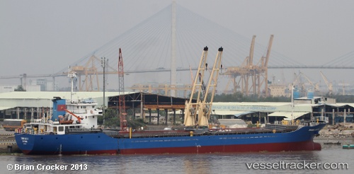
Truongloc16
Current StatusWhere is the vessel?
Truongloc16 is currently in 67 nm NE of Pulau Lang Lang, based on AIS data received about 14h ago.
Latest AIS update:
Current position: 8.41600° N, 114.28580° E (67 nm NE of Pulau Lang Lang)
Average speed (last 7 days): Loading…
Average speed (last 30 days): Loading…
Vessel profile: Truongloc16 is a General Cargo Ship with dimensions 16m x 92m.
This page combines live AIS, route history, probable destination signals, nearby traffic, and port activity for practical vessel monitoring.
The current position of vessel Truongloc16 is 8.41600 lat / 114.28580 lng. Updated: 2026-05-18 18:34:11 UTCNearest reference points:
- 159 nm N of Pulau Lang Lang
- 141 nm N of Pulau Lang Lang
- 142 nm N of Pulau Lang Lang
Details:
Live Vessel Truongloc16 Analytics (details, animations, etc.)
Recent AIS points (UTC):
2026-05-18 10:28:27 UTC · 8.56893, 113.29701 · SOG 7 kn · COG 114°2026-05-18 17:59:26 UTC · 8.42754, 114.21328 · SOG 7 kn · COG 100°
2026-05-18 18:34:11 UTC · 8.41600, 114.28580 · SOG 7 kn · COG 100°
2026-05-18 18:34:11 UTC · 8.41600, 114.28580 · SOG 7 kn · COG 100°