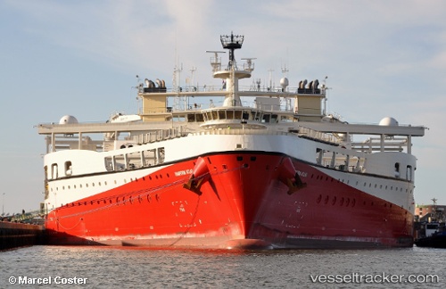
 RAMFORM ATLAS
Current Status
Where is the vessel?
RAMFORM ATLAS is currently in 31 nm SE of Craigellachie, based on AIS data received about 14h ago.
Latest AIS update:
Current position: 57.03833° N, 3.67333° E (31 nm SE of Craigellachie)
Average speed (last 7 days): Loading…
Average speed (last 30 days): Loading…
Vessel profile: RAMFORM ATLAS is a Research/Survey Vessel with dimensions m x m.
This page combines live AIS, route history, probable destination signals, nearby traffic, and port activity for practical vessel monitoring.
The current position of vessel RAMFORM ATLAS is 57.03833 lat / 3.67333 lng. Updated: 2026-05-20 09:18:13 UTCNearest reference points:
- 26 nm W of Cleghorn
- Near Egersund
- Near Lura
Currently sailing under the flag of Bahamas ![]()
Details:
Live Vessel RAMFORM ATLAS Analytics (details, animations, etc.)
Recent AIS points (UTC):
2026-05-20 07:09:10 UTC · 56.92167, 3.60500 · SOG 5 kn · COG -1°2026-05-20 08:03:10 UTC · 56.99500, 3.54500 · SOG 5 kn · COG -1°
2026-05-20 09:18:13 UTC · 57.03833, 3.67333 · SOG 4 kn · COG -1°
2026-05-20 09:18:13 UTC · 57.03833, 3.67333 · SOG 4 kn · COG -1°