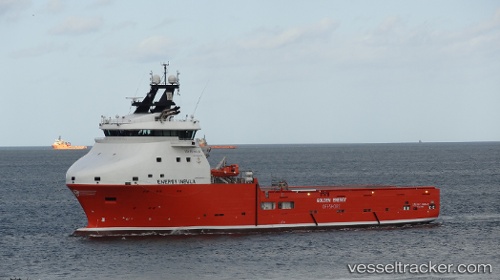
 Rem Insula
Current Status
Where is the vessel?
Rem Insula is currently in Near Molengat, based on AIS data received about 7d ago.
Latest AIS update:
Current position: 53.10742° N, 4.48697° E (Near Molengat)
Average speed (last 7 days): Loading…
Average speed (last 30 days): Loading…
Vessel profile: Rem Insula is a Offshore Tug Supply Ship with dimensions 86m x 20m.
This page combines live AIS, route history, probable destination signals, nearby traffic, and port activity for practical vessel monitoring.
The current position of vessel Rem Insula is 53.10742 lat / 4.48697 lng. Updated: 2026-05-11 16:58:06 UTCNearest reference points:
- Near Molengat
- Near Den Helder
- Near de Waal
Currently sailing under the flag of Bahamas ![]()
Details:
Live Vessel Rem Insula Analytics (details, animations, etc.)
Recent AIS points (UTC):
2026-05-11 16:58:06 UTC · 53.10742, 4.48697 · SOG 2 kn · COG 27°2026-05-11 16:58:06 UTC · 53.10742, 4.48697 · SOG 2 kn · COG 27°
2026-05-11 16:58:06 UTC · 53.10742, 4.48697 · SOG 2 kn · COG 27°
2026-05-11 16:58:06 UTC · 53.10742, 4.48697 · SOG 2 kn · COG 27°