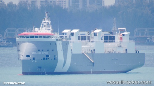
 GIROLANDO EXPRESS
Current Status
Where is the vessel?
GIROLANDO EXPRESS is currently in 28 nm W of Parit Raja, based on AIS data received about 15h ago.
Latest AIS update:
Current position: 1.69135° N, 102.67634° E (28 nm W of Parit Raja)
Average speed (last 7 days): Loading…
Average speed (last 30 days): Loading…
Vessel profile: GIROLANDO EXPRESS is a Cargo with dimensions m x m.
This page combines live AIS, route history, probable destination signals, nearby traffic, and port activity for practical vessel monitoring.
The current position of vessel GIROLANDO EXPRESS is 1.69135 lat / 102.67634 lng. Updated: 2026-05-22 19:28:44 UTCNearest reference points:
- 29 nm W of Parit Raja
- 12 nm S of Tangkak
- 17 nm NE of Perawang
Currently sailing under the flag of Portugal ![]()
Details:
Live Vessel GIROLANDO EXPRESS Analytics (details, animations, etc.)
Recent AIS points (UTC):
2026-05-22 16:04:17 UTC · 2.13307, 101.96668 · SOG 15.1 kn · COG -1°2026-05-22 18:22:09 UTC · 1.79407, 102.43072 · SOG 14.6 kn · COG 119°
2026-05-22 19:28:44 UTC · 1.69135, 102.67634 · SOG 14.1 kn · COG 114°
2026-05-22 19:28:44 UTC · 1.69135, 102.67634 · SOG 14.1 kn · COG 114°