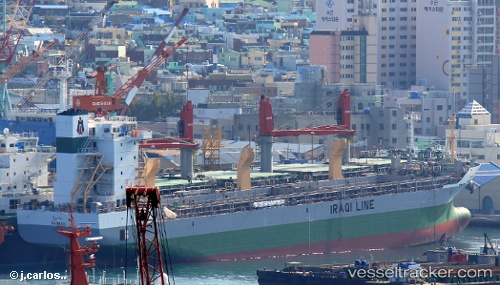
Basrah
Current StatusWhere is the vessel?
Basrah is currently in 29 nm SW of Jazireh-Ye Lavan, based on AIS data received about 15h ago.
Latest AIS update:
Current position: 26.49005° N, 52.90984° E (29 nm SW of Jazireh-Ye Lavan)
Average speed (last 7 days): Loading…
Average speed (last 30 days): Loading…
Vessel profile: Basrah is a Multi Purpose Carrier with dimensions 21m x 141m.
This page combines live AIS, route history, probable destination signals, nearby traffic, and port activity for practical vessel monitoring.
The current position of vessel Basrah is 26.49005 lat / 52.90984 lng. Updated: 2026-05-18 17:02:30 UTCNearest reference points:
- Near Jazireh-Ye Lavan
- 21 nm NE of Halul Island
- Near ASALUYEH
Details:
Live Vessel Basrah Analytics (details, animations, etc.)
Recent AIS points (UTC):
2026-05-18 17:02:30 UTC · 26.49005, 52.90984 · SOG 12.5 kn · COG 147°2026-05-18 17:02:30 UTC · 26.49005, 52.90984 · SOG 12.5 kn · COG 147°
2026-05-18 17:02:30 UTC · 26.49005, 52.90984 · SOG 12.5 kn · COG 147°
2026-05-18 17:02:30 UTC · 26.49005, 52.90984 · SOG 12.5 kn · COG 147°