 vesseltracker.com
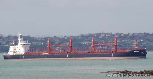
 NAVISION VINCENTZ
Current Status
Where is the vessel?
NAVISION VINCENTZ is currently in 17 nm SW of Montevideo, based on AIS data received about 15h ago.
Latest AIS update:
Current position: 35.16610° S, 56.38488° W (17 nm SW of Montevideo)
Average speed (last 7 days): Loading…
Average speed (last 30 days): Loading…
Vessel profile: NAVISION VINCENTZ is a Cargo with dimensions m x m.
This page combines live AIS, route history, probable destination signals, nearby traffic, and port activity for practical vessel monitoring.
The current position of vessel NAVISION VINCENTZ is -35.16610 lat / -56.38488 lng. Updated: 2026-05-17 22:12:58 UTCNearest reference points:
- 16 nm N of Cabo San Antonio
- 12 nm S of Piriápolis
- Near JUAN LACAZE
Currently sailing under the flag of Marshall Islands ![]()
Details:
Live Vessel NAVISION VINCENTZ Analytics (details, animations, etc.)
Recent AIS points (UTC):
2026-05-17 19:02:44 UTC · -34.99790, -55.94722 · SOG 9.2 kn · COG 278°2026-05-17 20:01:38 UTC · -34.98255, -56.06257 · SOG 4.9 kn · COG 222°
2026-05-17 22:00:02 UTC · -35.16928, -56.33762 · SOG 9.6 kn · COG 281°
2026-05-17 22:12:58 UTC · -35.16610, -56.38488 · SOG 11.3 kn · COG 269°