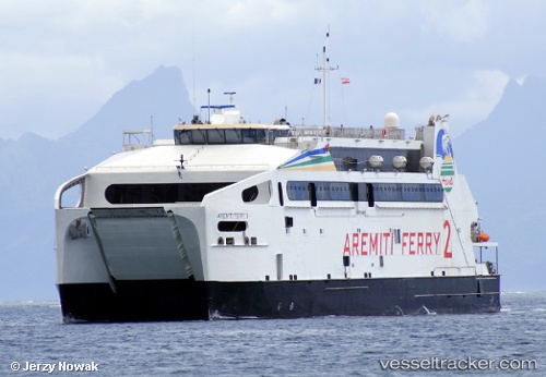
Aremiti Ferry Ii
Current StatusWhere is the vessel?
Aremiti Ferry Ii is currently in Near Papeete, based on AIS data received about 14h ago.
Latest AIS update:
Current position: 17.53748° S, 149.58382° W (Near Papeete)
Average speed (last 7 days): Loading…
Average speed (last 30 days): Loading…
Vessel profile: Aremiti Ferry Ii is a Passenger Ro Ro Cargo Ship with dimensions 17m x 80m.
This page combines live AIS, route history, probable destination signals, nearby traffic, and port activity for practical vessel monitoring.
The current position of vessel Aremiti Ferry Ii is -17.53748 lat / -149.58382 lng. Updated: 2026-05-22 17:52:55 UTCNearest reference points:
- 12 nm E of Papara
Details:
Live Vessel Aremiti Ferry Ii Analytics (details, animations, etc.)
Recent AIS points (UTC):
2026-05-22 14:03:45 UTC · -17.53513, -149.56979 · SOG 0 kn · COG 72°2026-05-22 16:06:15 UTC · -17.52442, -149.64937 · SOG 18.6 kn · COG 274°
2026-05-22 16:27:21 UTC · -17.52343, -149.76524 · SOG 18.3 kn · COG 277°
2026-05-22 17:52:55 UTC · -17.53748, -149.58382 · SOG 16 kn · COG 138°