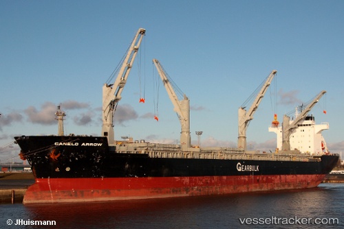
 Canelo Arrow
Current Status
Where is the vessel?
Canelo Arrow is currently in Near Mobile, based on AIS data received about 16h ago.
Latest AIS update:
Current position: 30.71044° N, 88.04202° W (Near Mobile)
Average speed (last 7 days): Loading…
Average speed (last 30 days): Loading…
Vessel profile: Canelo Arrow is a Multi Purpose Carrier with dimensions 189m x 31m.
This page combines live AIS, route history, probable destination signals, nearby traffic, and port activity for practical vessel monitoring.
The current position of vessel Canelo Arrow is 30.71044 lat / -88.04202 lng. Updated: 2026-05-21 22:04:48 UTCNearest reference points:
- Near Mobile
- Near Pinto Island
- Near Chickasaw
Currently sailing under the flag of Bahamas ![]()
Canelo Arrow built in 1997 year
Deadweight:
48077 tDetails:
Live Vessel Canelo Arrow Analytics (details, animations, etc.)
Recent AIS points (UTC):
2026-05-21 19:22:48 UTC · 30.71048, -88.04200 · SOG 0 kn · COG 301°2026-05-21 19:28:48 UTC · 30.71044, -88.04209 · SOG 0 kn · COG 301°
2026-05-21 21:40:48 UTC · 30.71053, -88.04203 · SOG 0 kn · COG 301°
2026-05-21 22:04:48 UTC · 30.71044, -88.04202 · SOG 0 kn · COG 301°