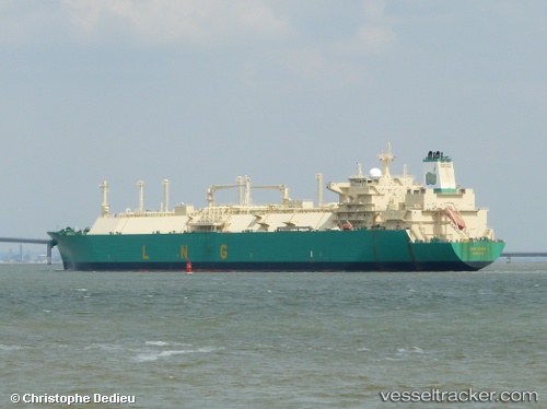
.

Lng Kano

Vessel type: Lng Tanker | IMO: 9311567 | MMSI: MMSI: 310534000
Call sign: ZCDT4 | Dimensions: 44 m x 278 m
Current Status

Where is the vessel?

Lng Kano is currently in 178 nm SE of Richards Bay, based on AIS data received about 14h ago.

Latest AIS update:

Current position: 31.13694° S, 34.32228° E (178 nm SE of Richards Bay)

Average speed (last 7 days): Loading…

Average speed (last 30 days): Loading…

Vessel profile: Lng Kano is a Lng Tanker with dimensions 44m x 278m.

This page combines live AIS, route history, probable destination signals, nearby traffic, and port activity for practical vessel monitoring.

The current position of vessel Lng Kano is -31.13694 lat / 34.32228 lng. Updated: 2026-05-22 10:59:07 UTC
More recent position available: 1 h 55 min ago
Free positions are delayed by 14 hours.

We recommend registering. If you register, paid vessel access will be saved in your profile. Guest access works only through a personal link.

Nearest reference points:
  • 181 nm SE of Hibberdene
  • 163 nm SE of Richards Bay
  • 125 nm SE of Port Edward
Details:

Live Vessel Lng Kano Analytics (details, animations, etc.)


Recent AIS points (UTC):
2026-05-22 07:22:48 UTC · -31.60767, 33.58929 · SOG 12.6 kn · COG 51°
2026-05-22 07:57:56 UTC · -31.53090, 33.70491 · SOG 12.9 kn · COG 51°
2026-05-22 09:56:28 UTC · -31.27842, 34.10952 · SOG 13 kn · COG 52°
2026-05-22 10:59:07 UTC · -31.13694, 34.32228 · SOG 13.3 kn · COG 57°

UTC: --
Start: -- Track timeline (UTC) End: --
Encountered: --


Link to the map:


Find another ship

Lng_Kano (310534000) last ports (portcalls and passsages)

Dahez SEZ | 2025-09-08 22:54:37
DAHEJ | 2025-09-08 22:04:27
Bonny | 2025-08-09 12:28:40
BUKOM ISLAND | 2025-07-06 07:45:29
BATU AMPAR | 2025-07-06 06:37:05
PENGERANG | 2025-07-06 04:56:59
WAILINGDING ISLAND | 2025-06-27 00:43:57
Bonny | 2025-05-21 17:38:50
Strait Of Gibraltar | 2025-03-13 15:17:52
TARIFA | 2025-03-13 12:46:21
SAINT LOUIS DU RHONE | 2025-03-09 21:16:43
LAVERA | 2025-03-09 19:24:48
Ceuta | 2025-03-06 10:55:34
Strait Of Gibraltar | 2025-03-06 09:25:46
Bonny | 2025-02-23 08:17:15
BAKAUHENI | 2025-01-05 15:22:24
PYEONGTAEK | 2024-12-22 23:42:58
DAESAN | 2024-12-22 21:18:12
Selat Sunda | 2024-12-10 04:03:05
Bonny | 2024-11-18 00:27:14
Gibraltar | 2024-10-22 14:53:00
Strait Of Gibraltar | 2024-10-22 11:31:22
St. Louis Du Rhone | 2024-10-18 07:04:18
Bonny | 2024-10-02 11:31:56
Port Louis | 2024-08-31 06:50:38
Mina Saud | 2024-08-11 20:15:30
Bonny | 2024-07-17 21:52:39
Port Elizabeth | 2024-06-22 13:12:29
Port Louis | 2024-06-12 12:06:54
Mina Saud | 2024-05-28 20:17:38
Bonny | 2024-05-04 22:20:37
Port Elizabeth | 2024-04-12 06:44:29
Bonny | 2024-02-22 00:50:45
Map Ta Phut | 2024-01-23 23:48:46
Singapore | 2024-01-21 17:34:39
Port Elizabeth | 2024-01-09 04:13:29
Bonny | 2023-12-29 14:24:36
Singapore | 2023-11-27 20:53:55
Port Louis | 2023-10-26 04:14:09
Bonny | 2023-10-11 09:34:51
Mina Saud | 2023-09-17 20:54:42
Bonny | 2023-08-26 06:48:59
Strait Of Gibraltar | 2023-08-16 08:51:37
Alicante | 2023-08-13 16:30:57
Bonny | 2023-07-26 18:56:01
Bonny | 2023-06-23 07:07:44
Port Louis | 2023-05-28 12:26:42
Bur Ibrahim | 2023-05-07 14:02:27
Port Said | 2023-05-07 03:02:50
Bonny | 2023-04-14 18:54:45
Bonny | 2023-02-21 14:50:49
Strait Of Gibraltar | 2023-01-23 12:08:09
Cartagena | 2023-01-19 11:11:00
Strait Of Gibraltar | 2023-01-16 08:07:01
Bonny | 2023-01-05 15:06:36
Bonny | 2022-11-04 08:30:50
Alicante | 2022-10-15 19:47:49
Bonny | 2022-10-03 19:15:03
Alicante | 2022-08-28 16:50:09
Alicante | 2022-08-24 13:02:04
Bonny | 2022-08-12 01:13:07
Bonny | 2022-06-04 16:42:31
Bonny | 2022-04-15 15:15:07
Strait Of Gibraltar | 2022-03-25 04:22:19
Cartagena | 2022-03-24 10:01:51
Bonny | 2022-03-11 09:30:24
Cartagena | 2022-02-18 08:00:24
Bonny | 2022-01-15 13:30:27
Singapore | 2021-12-17 06:30:39
Sambu | 2021-12-17 05:55:50
Higashi-Iwase | 2021-12-08 09:12:37