 ROUTE
ROUTE
Current Status
Where is the vessel?
ROUTE is currently in 100 nm NW of ABU QIR, based on AIS data received about 14h ago.
Latest AIS update:
Current position: 32.82459° N, 29.24728° E (100 nm NW of ABU QIR)
Average speed (last 7 days): Loading…
Average speed (last 30 days): Loading…
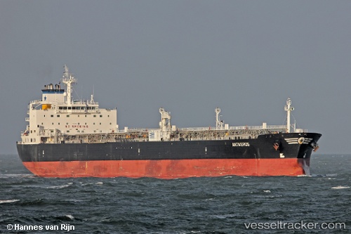
Vessel profile: ROUTE is a Crude Oil Tanker with dimensions 228m x 32m.
This page combines live AIS, route history, probable destination signals, nearby traffic, and port activity for practical vessel monitoring.
The current position of vessel ROUTE is 32.82459 lat / 29.24728 lng. Updated: 2026-05-20 04:23:18 UTCNearest reference points:
- 129 nm NW of ABU QIR
- 28 nm N of Hamra
- 108 nm S of Kastellorizou (ex Megísti)
Currently sailing under the flag of Barbados ![]()
ROUTE built in 2004 year
Deadweight:
69714 tDetails:
Live Vessel ROUTE Analytics (details, animations, etc.)
Recent AIS points (UTC):
2026-05-20 01:09:57 UTC · 32.99801, 28.50217 · SOG 12.2 kn · COG 106°2026-05-20 01:09:57 UTC · 32.99801, 28.50217 · SOG 12.2 kn · COG 106°
2026-05-20 04:23:18 UTC · 32.82459, 29.24728 · SOG 12.1 kn · COG 102°
2026-05-20 04:23:18 UTC · 32.82459, 29.24728 · SOG 12.1 kn · COG 102°