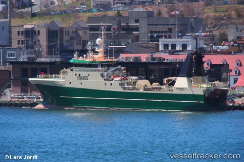
.
Vessel photo of Katsheshuk Ii (IMO 9127174) vesseltracker.com

CA flag Katsheshuk Ii

Vessel type: Fishing Vessel | IMO: 9127174 | MMSI: MMSI: 316319000
Call sign: VAAI | Dimensions: 60 m x 13 m
Current Status

Where is the vessel?

Katsheshuk Ii is currently in 74 nm N of White Rose Field, based on AIS data received about 14h ago.

Latest AIS update:

Current position: 48.00703° N, 48.12681° W (74 nm N of White Rose Field)

Average speed (last 7 days): Loading…

Average speed (last 30 days): Loading…

Vessel profile: Katsheshuk Ii is a Fishing Vessel with dimensions 60m x 13m.

This page combines live AIS, route history, probable destination signals, nearby traffic, and port activity for practical vessel monitoring.

The current position of vessel Katsheshuk Ii is 48.00703 lat / -48.12681 lng. Updated: 2026-05-18 01:01:06 UTC
More recent position available: 2 h 12 min ago

Shipinfo shows free vessel positions with a delay. After payment, you will be able to view the current position of this vessel for 24 hours.

We recommend registering. If you register, paid vessel access will be saved in your profile. Guest access works only through a personal link.

Nearest reference points:
  • 24 nm SW of White Rose Field

Currently sailing under the flag of Canada CA flag

Katsheshuk Ii built in 1995 year

Deadweight:
700 t

Details:

Live Vessel Katsheshuk Ii Analytics (details, animations, etc.)


Recent AIS points (UTC):
2026-05-17 21:50:32 UTC · 48.19833, -48.75167 · SOG 10 kn · COG -1°
2026-05-17 22:26:33 UTC · 48.14667, -48.63167 · SOG 9 kn · COG -1°
2026-05-18 00:17:32 UTC · 48.03167, -48.28500 · SOG 8 kn · COG -1°
2026-05-18 01:01:06 UTC · 48.00703, -48.12681 · SOG 9.6 kn · COG 110°

UTC: --
Start: -- Track timeline (UTC) End: --
Encountered: --


Link to the map:


Find another ship

Katsheshuk_Ii (316319000) last ports (portcalls and passsages)

ST JOHNS | 2025-08-05 02:54:26
ST JOHNS | 2025-08-01 02:13:02
ST JOHNS | 2025-07-28 00:52:51
ST JOHNS | 2025-07-24 00:17:39
ST JOHNS | 2025-07-19 23:53:28
ST JOHNS | 2025-07-15 22:48:41
ST JOHNS | 2025-07-11 22:36:36
ST JOHNS | 2025-07-07 22:16:53
ST JOHNS | 2025-07-03 21:22:10
ST JOHNS | 2025-06-29 19:48:24
ST JOHNS | 2025-06-25 18:47:49
ST JOHNS | 2025-06-21 18:14:41
ST JOHNS | 2025-06-17 17:30:28
ST JOHNS | 2025-06-13 17:07:40
ST JOHNS | 2025-06-09 16:36:10
ST JOHNS | 2025-06-05 15:52:07
ST JOHNS | 2025-04-09 11:22:33
LONG POND | 2024-12-21 19:18:35
St. John’S | 2024-07-06 11:14:39
St. John’S | 2024-06-29 14:32:35
St. John’S | 2024-06-02 05:24:53
St. John’S | 2024-05-17 16:26:43
St. John’S | 2024-05-07 12:52:12
St. John’S | 2024-05-03 12:25:41
St. John’S | 2024-04-29 12:22:12
St. John’S | 2024-04-25 11:35:31
St. John’S | 2024-04-21 10:35:29
St. John’S | 2024-04-17 10:27:56
St. John’S | 2024-04-13 08:59:50
Argentia | 2024-04-11 01:47:41
Argentia | 2024-04-07 01:16:54
St. John’S | 2024-02-05 23:12:30
St. John’S | 2023-12-15 20:36:46
St. John’S | 2023-12-09 09:21:18
St. John’S | 2023-12-05 08:41:26
St. John’S | 2023-12-01 08:14:10
St. John’S | 2023-11-27 07:07:35
St. John’S | 2023-11-23 06:11:53
St. John’S | 2023-11-19 06:09:54
St. John’S | 2023-11-15 04:50:29
St. John’S | 2023-11-11 04:23:39
St. John’S | 2023-11-07 04:05:35
St. John’S | 2023-11-03 02:48:22
St. John’S | 2023-10-30 02:01:32
St. John’S | 2023-10-26 01:59:57
St. John’S | 2023-10-22 01:53:11
St. John’S | 2023-10-18 01:18:11
St. John’S | 2023-10-14 00:33:05
St. John’S | 2023-10-10 00:32:38
St. John’S | 2023-10-06 00:23:16
St. John’S | 2023-10-01 22:14:24
St. John’S | 2023-09-27 21:27:40
St. John’S | 2023-09-23 20:43:18
St. John’S | 2023-09-19 20:24:08
St. John’S | 2023-09-15 18:23:45
St. John’S | 2023-09-11 18:03:42
St. John’S | 2023-09-07 17:28:37
St. John’S | 2023-09-03 17:27:44
St. John’S | 2023-08-30 17:21:16
St. John’S | 2023-08-26 16:38:28
St. John’S | 2023-08-22 15:43:57
St. John’S | 2023-07-18 21:37:58
St. John’S | 2023-07-06 09:29:54