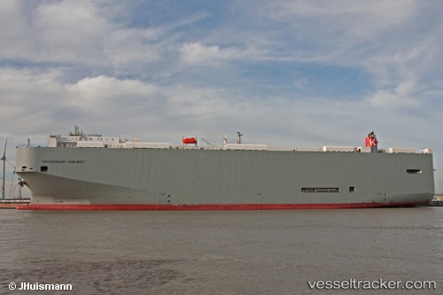
 Chesapeake Highway
Current Status
Where is the vessel?
Chesapeake Highway is currently in Near Ramskapelle, based on AIS data received about 14h ago.
Latest AIS update:
Current position: 51.30172° N, 3.23730° E (Near Ramskapelle)
Average speed (last 7 days): Loading…
Average speed (last 30 days): Loading…
Vessel profile: Chesapeake Highway is a Vehicles Carrier with dimensions 200m x 32m.
This page combines live AIS, route history, probable destination signals, nearby traffic, and port activity for practical vessel monitoring.
The current position of vessel Chesapeake Highway is 51.30172 lat / 3.23730 lng. Updated: 2026-05-22 10:03:50 UTCNearest reference points:
- Near Zeebrugge
- Near Sas-Slijkens
- Near Oostende
Currently sailing under the flag of Panama ![]()
Chesapeake Highway built in 2010 year
Deadweight:
21643 tDetails:
Live Vessel Chesapeake Highway Analytics (details, animations, etc.)
Recent AIS points (UTC):
2026-05-22 07:06:48 UTC · 51.30171, 3.23729 · SOG 0 kn · COG 332°2026-05-22 08:15:46 UTC · 51.30172, 3.23728 · SOG 0 kn · COG 332°
2026-05-22 09:21:51 UTC · 51.30171, 3.23730 · SOG 0 kn · COG 332°
2026-05-22 10:03:50 UTC · 51.30172, 3.23730 · SOG 0 kn · COG 332°