 vesseltracker.com
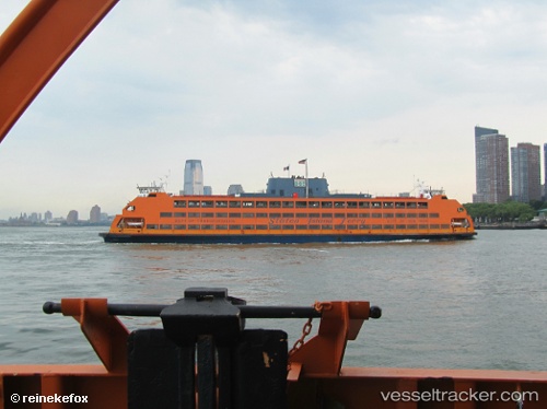
 Samuel I Newhouse
Current Status
Where is the vessel?
Samuel I Newhouse is currently in Near Tompkinsville, based on AIS data received about 15h ago.
Latest AIS update:
Current position: 40.64450° N, 74.07183° W (Near Tompkinsville)
Average speed (last 7 days): Loading…
Average speed (last 30 days): Loading…
Vessel profile: Samuel I Newhouse is a Passenger Ro Ro Cargo Ship with dimensions 95m x 22m.
This page combines live AIS, route history, probable destination signals, nearby traffic, and port activity for practical vessel monitoring.
The current position of vessel Samuel I Newhouse is 40.64450 lat / -74.07183 lng. Updated: 2026-05-18 07:01:45 UTCNearest reference points:
- Near Tompkinsville
- Near Maher Terminal
- Near Brooklyn
Currently sailing under the flag of USA ![]()
Samuel I Newhouse built in 1982 year
Deadweight:
2250 tDetails:
Live Vessel Samuel I Newhouse Analytics (details, animations, etc.)
Recent AIS points (UTC):
2026-05-18 04:23:41 UTC · 40.69582, -74.02009 · SOG 12.9 kn · COG 59°2026-05-18 04:39:15 UTC · 40.69391, -74.02667 · SOG 15.5 kn · COG 47°
2026-05-18 06:04:54 UTC · 40.64863, -74.05846 · SOG 14.4 kn · COG 46°
2026-05-18 07:01:45 UTC · 40.64450, -74.07183 · SOG 0.1 kn · COG 235°