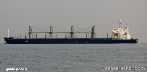
Matakana Island
Current StatusWhere is the vessel?
Matakana Island is currently in 56 nm N of Kikaishima, based on AIS data received about 14h ago.
Latest AIS update:
Current position: 29.21010° N, 129.65323° E (56 nm N of Kikaishima)
Average speed (last 7 days): Loading…
Average speed (last 30 days): Loading…
Vessel profile: Matakana Island is a Bulk Carrier with dimensions 30m x 175m.
This page combines live AIS, route history, probable destination signals, nearby traffic, and port activity for practical vessel monitoring.
The current position of vessel Matakana Island is 29.21010 lat / 129.65323 lng. Updated: 2026-05-21 00:22:38 UTCNearest reference points:
- 18 nm W of Koniya
- 71 nm SW of Taniyama
- Near YAMAGAWA
Details:
Live Vessel Matakana Island Analytics (details, animations, etc.)
Recent AIS points (UTC):
2026-05-20 19:08:43 UTC · 28.43247, 130.56020 · SOG 12.9 kn · COG 315°2026-05-20 21:33:25 UTC · 28.81981, 130.15454 · SOG 12.9 kn · COG 316°
2026-05-20 22:59:53 UTC · 29.03027, 129.90553 · SOG 12.5 kn · COG 308°
2026-05-21 00:22:38 UTC · 29.21010, 129.65323 · SOG 12.1 kn · COG 317°