Rahmat
Current StatusWhere is the vessel?
Rahmat is currently in 129 nm S of Grobogan, based on AIS data received about 5d ago.
Latest AIS update:
Current position: 5.03500° N, 111.08167° E (129 nm S of Grobogan)
Average speed (last 7 days): Loading…
Average speed (last 30 days): Loading…
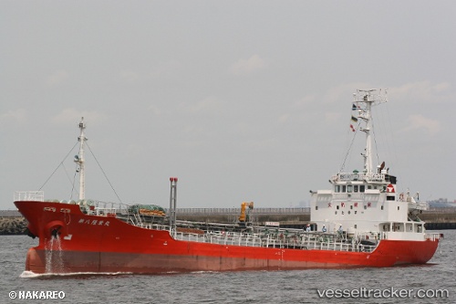
Vessel profile: Rahmat is a Oil Products Tanker with dimensions 11m x 75m.
This page combines live AIS, route history, probable destination signals, nearby traffic, and port activity for practical vessel monitoring.
The current position of vessel Rahmat is 5.03500 lat / 111.08167 lng. Updated: 2026-05-15 12:17:23 UTCNearest reference points:
- 42 nm W of BINTULU
- 28 nm SW of BINTULU
- 34 nm SE of Ranai
Details:
Live Vessel Rahmat Analytics (details, animations, etc.)
Recent AIS points (UTC):
2026-05-15 12:17:23 UTC · 5.03500, 111.08167 · SOG 7 kn · COG -1°2026-05-15 12:17:23 UTC · 5.03500, 111.08167 · SOG 7 kn · COG -1°
2026-05-15 12:17:23 UTC · 5.03500, 111.08167 · SOG 7 kn · COG -1°
2026-05-15 12:17:23 UTC · 5.03500, 111.08167 · SOG 7 kn · COG -1°