 ENDEAVOUR
Current Status
Where is the vessel?
ENDEAVOUR is currently in Near Papeete, based on AIS data received about 14h ago.
Latest AIS update:
Current position: 17.53377° S, 149.57243° W (Near Papeete)
Average speed (last 7 days): Loading…
Average speed (last 30 days): Loading…
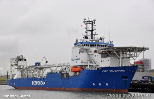
Vessel profile: ENDEAVOUR is a Offshore Support Vessel with dimensions 22m x 130m.
This page combines live AIS, route history, probable destination signals, nearby traffic, and port activity for practical vessel monitoring.
The current position of vessel ENDEAVOUR is -17.53377 lat / -149.57243 lng. Updated: 2026-05-21 10:39:49 UTCNearest reference points:
- 12 nm E of Papara
Currently sailing under the flag of Marshall Islands ![]()
ENDEAVOUR built in 1999 year
Deadweight:
8376 tDetails:
Live Vessel ENDEAVOUR Analytics (details, animations, etc.)
Recent AIS points (UTC):
2026-05-21 07:26:42 UTC · -17.53379, -149.57243 · SOG 0 kn · COG 296°2026-05-21 07:42:49 UTC · -17.53379, -149.57243 · SOG 0 kn · COG 296°
2026-05-21 10:14:36 UTC · -17.53377, -149.57243 · SOG 0 kn · COG 296°
2026-05-21 10:39:49 UTC · -17.53377, -149.57243 · SOG 0 kn · COG 296°