 vesseltracker.com
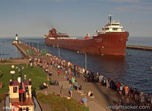
Lee A Tregurtha
Current StatusWhere is the vessel?
Lee A Tregurtha is currently in Near INDIANA HARBOR, based on AIS data received about 14h ago.
Latest AIS update:
Current position: 41.67545° N, 87.43787° W (Near INDIANA HARBOR)
Average speed (last 7 days): Loading…
Average speed (last 30 days): Loading…
Vessel profile: Lee A Tregurtha is a Self Discharging Bulk Carrier with dimensions 24m x 252m.
This page combines live AIS, route history, probable destination signals, nearby traffic, and port activity for practical vessel monitoring.
The current position of vessel Lee A Tregurtha is 41.67545 lat / -87.43787 lng. Updated: 2026-05-18 12:01:51 UTCNearest reference points:
- Near Burnham
- Near Burns Harbor
- Near WAUKEGAN
Details:
Live Vessel Lee A Tregurtha Analytics (details, animations, etc.)
Recent AIS points (UTC):
2026-05-18 08:16:52 UTC · 41.67545, -87.43788 · SOG 0 kn · COG 344°2026-05-18 09:57:21 UTC · 41.67500, -87.43667 · SOG 0 kn · COG -1°
2026-05-18 11:07:49 UTC · 41.67546, -87.43789 · SOG 0 kn · COG 344°
2026-05-18 12:01:51 UTC · 41.67545, -87.43787 · SOG 0 kn · COG 344°