 Pacific Santa Ana
Current Status
Where is the vessel?
Pacific Santa Ana is currently in Near Vridi, based on AIS data received about 14h ago.
Latest AIS update:
Current position: 5.21990° N, 4.02371° W (Near Vridi)
Average speed (last 7 days): Loading…
Average speed (last 30 days): Loading…
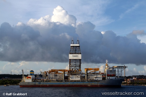
Vessel profile: Pacific Santa Ana is a Drilling Ship with dimensions 228m x 42m.
This page combines live AIS, route history, probable destination signals, nearby traffic, and port activity for practical vessel monitoring.
The current position of vessel Pacific Santa Ana is 5.21990 lat / -4.02371 lng. Updated: 2026-05-20 04:35:46 UTCNearest reference points:
- Near Vridi
- Near Abidjan
- Near Espoir
Currently sailing under the flag of Liberia ![]()
Pacific Santa Ana built in 2011 year
Deadweight:
58830 tDetails:
Live Vessel Pacific Santa Ana Analytics (details, animations, etc.)
Recent AIS points (UTC):
2026-05-20 01:16:05 UTC · 5.22062, -4.02211 · SOG 0.1 kn · COG 209°2026-05-20 01:58:05 UTC · 5.22065, -4.02189 · SOG 0 kn · COG 230°
2026-05-20 04:16:05 UTC · 5.22009, -4.02380 · SOG 0.1 kn · COG 125°
2026-05-20 04:35:46 UTC · 5.21990, -4.02371 · SOG 0 kn · COG 137°