 vesseltracker.com
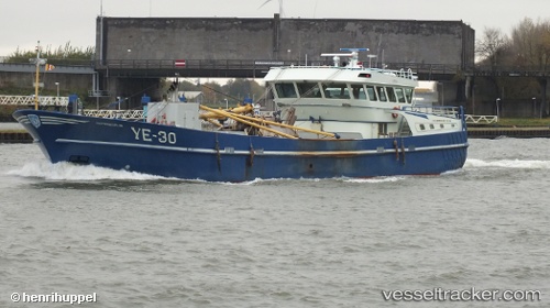
 WR2 DUNJA LYNN
Current Status
Where is the vessel?
WR2 DUNJA LYNN is currently in Near Wieringen/Den Oever, based on AIS data received about 14h ago.
Latest AIS update:
Current position: 52.93514° N, 5.03568° E (Near Wieringen/Den Oever)
Average speed (last 7 days): Loading…
Average speed (last 30 days): Loading…
Vessel profile: WR2 DUNJA LYNN is a Fishing Vessel with dimensions m x m.
This page combines live AIS, route history, probable destination signals, nearby traffic, and port activity for practical vessel monitoring.
The current position of vessel WR2 DUNJA LYNN is 52.93514 lat / 5.03568 lng. Updated: 2026-05-17 22:43:01 UTCNearest reference points:
- Near DEN OEVER
- Near MARINA DEN OEVER
- Near OUDESCHILD
Currently sailing under the flag of Netherlands ![]()
Details:
Live Vessel WR2 DUNJA LYNN Analytics (details, animations, etc.)
Recent AIS points (UTC):
2026-05-17 19:32:01 UTC · 52.93512, 5.03566 · SOG 0 kn · COG -1°2026-05-17 20:09:12 UTC · 52.93510, 5.03564 · SOG 0 kn · COG -1°
2026-05-17 21:43:21 UTC · 52.93512, 5.03568 · SOG 0 kn · COG -1°
2026-05-17 22:43:01 UTC · 52.93514, 5.03568 · SOG 0 kn · COG -1°