 vesseltracker.com
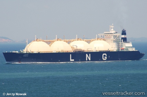
 Mubaraz
Current Status
Where is the vessel?
Mubaraz is currently in Near Taku Bar, based on AIS data received about 16h ago.
Latest AIS update:
Current position: 38.81222° N, 118.09872° E (Near Taku Bar)
Average speed (last 7 days): Loading…
Average speed (last 30 days): Loading…
Vessel profile: Mubaraz is a Lng Tanker with dimensions 290m x 48m.
This page combines live AIS, route history, probable destination signals, nearby traffic, and port activity for practical vessel monitoring.
The current position of vessel Mubaraz is 38.81222 lat / 118.09872 lng. Updated: 2026-05-18 04:15:20 UTCNearest reference points:
- Near Taku Bar
- Near Dagu Bar
- 15 nm SE of Taku Bar
Currently sailing under the flag of Liberia ![]()
Mubaraz built in 1996 year
Deadweight:
72950 tDetails:
Live Vessel Mubaraz Analytics (details, animations, etc.)
Recent AIS points (UTC):
2026-05-18 01:37:28 UTC · 38.92756, 117.87614 · SOG 0 kn · COG 107°2026-05-18 01:46:26 UTC · 38.92756, 117.87614 · SOG 0 kn · COG 107°
2026-05-18 03:30:02 UTC · 38.86814, 117.97665 · SOG 9.9 kn · COG 121°
2026-05-18 04:15:20 UTC · 38.81222, 118.09872 · SOG 6.8 kn · COG 122°