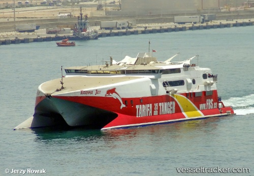
 TARIFA JET
Current Status
Where is the vessel?
TARIFA JET is currently in Near JERSEY, based on AIS data received about 16h ago.
Latest AIS update:
Current position: 49.17791° N, 2.11667° W (Near JERSEY)
Average speed (last 7 days): Loading…
Average speed (last 30 days): Loading…
Vessel profile: TARIFA JET is a High speed craft with dimensions m x m.
This page combines live AIS, route history, probable destination signals, nearby traffic, and port activity for practical vessel monitoring.
The current position of vessel TARIFA JET is 49.17791 lat / -2.11667 lng. Updated: 2026-05-20 07:31:11 UTCNearest reference points:
- Near Barneville-Carteret
- Near GUERNSEY
- Near SAINT SAMPSON
Currently sailing under the flag of United Kingdom ![]()
Details:
Live Vessel TARIFA JET Analytics (details, animations, etc.)
Recent AIS points (UTC):
2026-05-20 04:33:21 UTC · 48.64115, -2.02841 · SOG 0 kn · COG 261°2026-05-20 05:50:27 UTC · 48.70094, -2.08042 · SOG 14.6 kn · COG 20°
2026-05-20 07:23:32 UTC · 49.17242, -2.11945 · SOG 8.7 kn · COG 16°
2026-05-20 07:31:11 UTC · 49.17791, -2.11667 · SOG 0.1 kn · COG 158°