 Sch24 Afrika
Current Status
Where is the vessel?
Sch24 Afrika is currently in 26 nm SW of Ham Voe, Foula, based on AIS data received about 15h ago.
Latest AIS update:
Current position: 59.95289° N, 2.82886° W (26 nm SW of Ham Voe, Foula)
Average speed (last 7 days): Loading…
Average speed (last 30 days): Loading…
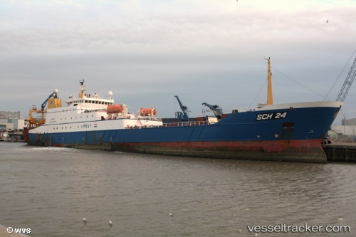
Vessel profile: Sch24 Afrika is a Fishing Vessel with dimensions 126m x 16m.
This page combines live AIS, route history, probable destination signals, nearby traffic, and port activity for practical vessel monitoring.
The current position of vessel Sch24 Afrika is 59.95289 lat / -2.82886 lng. Updated: 2026-05-20 01:56:54 UTCNearest reference points:
- 36 nm NW of Ham Voe, Foula
- 32 nm NW of Eshaness
- Near Tingwall
Currently sailing under the flag of Netherlands ![]()
Sch24 Afrika built in 1999 year
Deadweight:
6400 tDetails:
Live Vessel Sch24 Afrika Analytics (details, animations, etc.)
Recent AIS points (UTC):
2026-05-19 23:04:19 UTC · 60.39500, -3.41333 · SOG 9 kn · COG -1°2026-05-20 00:11:54 UTC · 60.23572, -3.19756 · SOG 11.1 kn · COG 147°
2026-05-20 01:13:34 UTC · 60.07692, -2.99053 · SOG 11.5 kn · COG 145°
2026-05-20 01:56:54 UTC · 59.95289, -2.82886 · SOG 13 kn · COG 146°