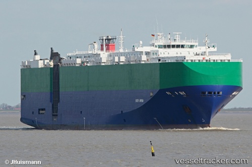
Ivory Arrow
Current StatusWhere is the vessel?
Ivory Arrow is currently in 273 nm SE of Abakaliki, based on AIS data received about 14h ago.
Latest AIS update:
Current position: 2.19500° N, 87.87833° E (273 nm SE of Abakaliki)
Average speed (last 7 days): Loading…
Average speed (last 30 days): Loading…
Vessel profile: Ivory Arrow is a Vehicles Carrier with dimensions 32m x 200m.
This page combines live AIS, route history, probable destination signals, nearby traffic, and port activity for practical vessel monitoring.
The current position of vessel Ivory Arrow is 2.19500 lat / 87.87833 lng. Updated: 2026-05-22 10:28:52 UTCNearest reference points:
- 331 nm S of Abakaliki
- Open sea, approx. 400 nm off the nearest listed port
- Open sea, approx. 401 nm off the nearest listed port
Details:
Live Vessel Ivory Arrow Analytics (details, animations, etc.)
Recent AIS points (UTC):
2026-05-22 07:13:51 UTC · 2.62667, 87.14667 · SOG 15 kn · COG -1°2026-05-22 07:43:52 UTC · 2.55833, 87.25833 · SOG 15 kn · COG -1°
2026-05-22 09:46:53 UTC · 2.28667, 87.71500 · SOG 15 kn · COG -1°
2026-05-22 10:28:52 UTC · 2.19500, 87.87833 · SOG 16 kn · COG -1°