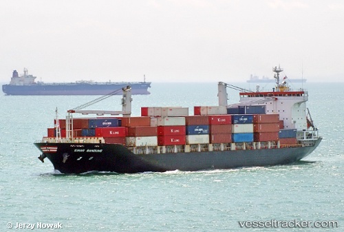
 Sinar Bandung
Current Status
Where is the vessel?
Sinar Bandung is currently in 62 nm E of Kampung Jawa, based on AIS data received about 15h ago.
Latest AIS update:
Current position: 2.43477° N, 104.58801° E (62 nm E of Kampung Jawa)
Average speed (last 7 days): Loading…
Average speed (last 30 days): Loading…
Vessel profile: Sinar Bandung is a Container Ship with dimensions 147m x 25m.
This page combines live AIS, route history, probable destination signals, nearby traffic, and port activity for practical vessel monitoring.
The current position of vessel Sinar Bandung is 2.43477 lat / 104.58801 lng. Updated: 2026-05-18 19:25:46 UTCNearest reference points:
- 64 nm NE of PENGERANG
- 53 nm NE of PENGERANG
- 52 nm NE of PENGERANG
Currently sailing under the flag of Singapore ![]()
Sinar Bandung built in 2005 year
Deadweight:
14984 tDetails:
Live Vessel Sinar Bandung Analytics (details, animations, etc.)
Recent AIS points (UTC):
2026-05-18 13:59:35 UTC · 3.51322, 103.87745 · SOG 14.3 kn · COG 142°2026-05-18 17:23:47 UTC · 2.86258, 104.38346 · SOG 14.4 kn · COG 143°
2026-05-18 19:25:46 UTC · 2.43477, 104.58801 · SOG 14 kn · COG -1°
2026-05-18 19:25:46 UTC · 2.43477, 104.58801 · SOG 14 kn · COG -1°